
 Submit a Paper
 Propose a Special lssue
 Open Access
ARTICLE

Suitability Evaluation for Urban Green Space Areas in Sèmè-Podji District (Southern Benin), Using GIS and AHP Methods
1 Unité de Recherche Horticole et d’Aménagement des Espaces Verts, Laboratoire des Sciences Végétales, Horticoles et Forestières, École d’Horticulture et d’Aménagement des Espaces Verts, Université Nationale d’Agriculture, P.O. Box 43, Kétou, 229, Benin
2 Unité de Recherche en Foresterie et Conservation des BioRessources, Laboratoire de Sciences Végétales, Horticoles et Forestières, École de Foresterie Tropicale, Université Nationale d’Agriculture, P.O. Box 43, Kétou, 229, Benin
* Corresponding Author: Gbodja Houéhanou François Gbesso. Email:
Revue Internationale de Géomatique 2024, 33, 201-220. https://doi.org/10.32604/rig.2024.053500
Received 01 May 2024; Accepted 18 June 2024; Issue published 11 July 2024
 View Full Text
 Download PDF
Abstract
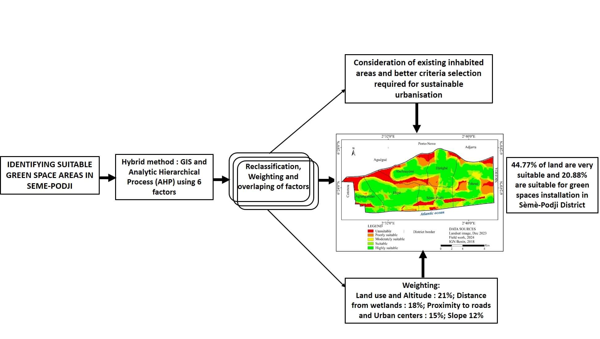
Urban green areas play a vital role in enhancing the social balance, resilience, and environmental sustainability of urban settings. In Benin, while the landscaping sector is expanding, finding appropriate locations for creating green spaces remains a challenge. The purpose of this study was to identify areas conducive to the incorporation of green landscapes into urban planning within the Sèmè-Podji District. The approach used involved a multi-criteria analysis leveraging a combined GIS and Analytic Hierarchy Process (AHP) framework. Six key factors were considered: land use, elevation, slope, distance to major roads, proximity to urban hubs, and separation from flood-prone zones and water bodies. These were analyzed using the “Spatial Analysis” feature of ArcGIS to create a map highlighting areas suitable for the development of green spaces. The findings reveal that a substantial portion of land, approximately 44.77%, is highly favorable, and 20.88% suitable for landscaping in this district. The weighting of factors combined in this analysis reveals a 21% importance for land use and elevation, while distance from separation from flood-prone zones is given a weight of 18%. Distance to major roads and proximity to urban hubs are weighted at 15%, against 12% for the slope factor. This information provides guidance to decision-makers in selecting suitable sites for green spaces and their integration into the land management of Sèmè-Podji District. The results of this study also provide a scientific basis for addressing similar concerns in other cities.Graphic Abstract
Keywords
Green spaces are a component of land planning aimed at meeting both the social and environmental demand of cities [1,2]. Their presence enhances the attractiveness of territories while contributing to the balance of ecosystems and the maintenance of biodiversity within cities [3,4]. Increasingly, they are being integrated into land planning as a spatial planning tool intended to beautify cities and improve the quality of life for residents [5].
Given the countless benefits that green spaces provide to populations and living environments, their implementation requires standards, particularly with regard to their spatial distribution and the selection of sites suitable for their installation and sustainability [6,7]. In this context, a minimum of 10 m2 of green space per inhabitant has been recommended in sustainable development programs for territories [8]. Thus, in countries where the development of green spaces is a priority in urban planning, efforts are made to adhere to these standards to ensure a balance between living environments and urban populations [9,10]. Conversely, some cities struggle to meet these conventional norms, due to the limited attention urban managers pay to green spaces [11,12].
This is the case in Sèmè-Podji District, which is a transitional territory between two major cities in southern Benin: Cotonou, the largest economic hub, and Porto-Novo, the political capital of the country [13]. This geographical position influences the demographic growth of the District, given the residential comfort it offers and its proximity to the country’s major economic activity centers. Currently, the Sèmè-Podji District is experiencing a rapid population increase due to urban expansion driven by the city of Cotonou. From 2002 to 2013, the district witnessed an intercensal growth rate of 6%, and now comprises 20.2% of the population in the Ouémé department, positioning it among the commuter towns of southern Benin [14]. Despite demographic growth and existing urban planning, this area boasts merely one public green space, constituting just 0.008% of the district’s total area, with a per capita green space availability of 0.06 m2 [11]. The predominant reasons for this scarcity of green spaces include insufficient strategic initiatives for securing land, human, and financial resources required for landscape development across the district’s successive local development initiatives. This has led to a notable deficiency in ecosystem services, including carbon sequestration by trees [15], air oxygenation, moisture regulation [16], soil erosion control [17], and improved thermal comfort [18].
Confronted with these issues, it is crucial to pinpoint potential land resources near urban areas that can be developed into green spaces in a sustainable manner. To facilitate this, many studies have already implemented a GIS-based multicriteria analysis to pinpoint optimal locations for creating green spaces [19–21]. This method plays a critical role in the strategic selection of sites for establishing socio-cultural and environmental facilities as part of sustainable urban planning and management [22]. For example, some authors [23] thing that it becomes highly necessary to determine suitable sites for landfill in Ajaokuta, Nigeria. In order to obtain the maximum efficiency in the selection of appropriate land for this activity, they used remote sensing and GIS tools to identify the scenes of present dump sites. More specifically, in the field of spatial planning, combining GIS and the Analytic Hierarchy Process (AHP) allows for accurately determining territories suitable for green space development, while ensuring accessibility to users [24–27].
Accessibility to key studies suggests that GIS and hierarchical multicriteria analysis alone may not meet the precision needed for choosing locations for socio-cultural and environmental infrastructures. It has been demonstrated that these tools are more suitable for recommending locations for green space creation in city areas. Yet, no specific investigation using this methodology has been conducted to create a suitability map for the sustainable development of green spaces in the Sèmè-Podji District, which includes a significant Ramsar site, number 1018, in Benin. Moreover, the district is integral to the national development plans for robust green infrastructure projects. Therefore, it is crucial to proactively identify areas that could be sustainably developed for future projects. This study was launched to provide a practical and scientific foundation for multiple cities, aiming to define areas appropriate for green space development and to incorporate these elements into the urban planning of Sèmè-Podji District in Benin.
The Sèmè-Podji district, positioned in the Ouémé department to the southeast of Benin, lies along the coast of the Atlantic Ocean. Geographically, it spans from 6°19′59″ to 6°27′34″ north latitude and from 2°27′42″ to 2°42′34″ east longitude. It is bordered to the north by the districts of Porto-Novo, Aguégués, Sô-Ava, and Adjarra, to the south by the Atlantic Ocean, to the east by the Federal Republic of Nigeria, and to the west by the Cotonou District. Sèmè-Podji district is divided into six subdivisions: Agblangandan, Aholouyèmè, Tohouè, Sèmè-Podji, Djèrègbé, and Ekpè, covering a total area of250 km2 (Fig. 1). The most recent census reported a population of 222,701, with 113,107 women [14]. The district is culturally diverse, home to the Défis, Xwla, and Seto groups, the latter of which share cultural ties with the Gouns of the Porto-Novo region. The district’s climate is classified as Sudanese-Guinean, featuring two dry and two rainy seasons, with an average temperature of 27°C and a high humidity level. Annual rainfall averages 1100 mm, influenced by periodic coastal winds, making it one of the wettest regions in southern Benin. The soil here is predominantly hydromorphic, shaped by the leaching and sedimentation of the Benin coastal plain. The district’s extensive hydrographic network includes the Atlantic Ocean, the Porto-Novo lagoon, the Ouémé river, and Lake Nokoué. This region’s vegetation, part of the Guinean coastal phytogeographic sector, predominantly consists of shrubs and underbrush, which are gradually diminishing due to expanding human settlements [28]. These biophysical attributes significantly impact the planning and persistence of urban green spaces, the focus of this study.
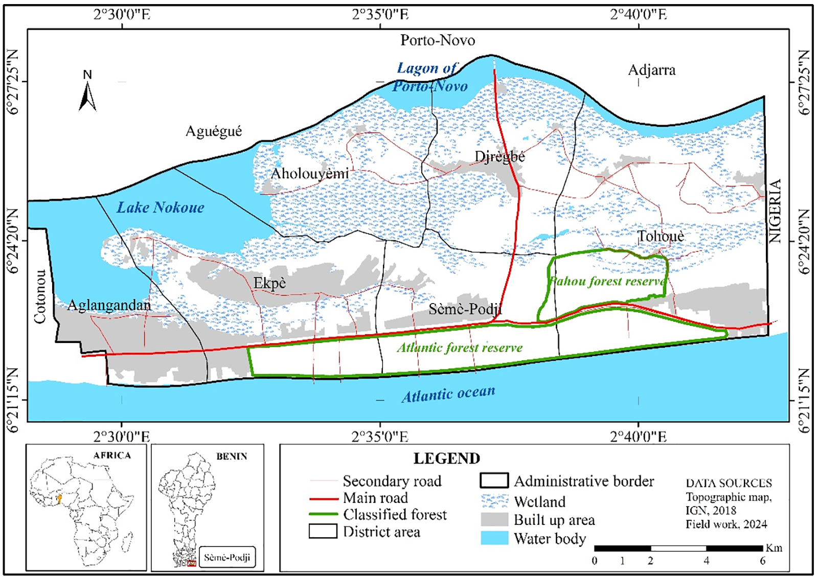
Figure 1: Location of Benin in West Africa and Sèmè-Podji district in Benin
2.2 Data Collection for the Identification for Suitable Green Spaces Areas
To determine the environmental and social factors influencing the establishment and sustainability of green spaces in the Sèmè-Podji District, various sources of information were used. This information takes into account the desirable environmental quality from existing situation and greening standards. Moreover, the urban planning context such as public opinion and the description of the physical characteristics in the study area are required.
For the greening standards information, they are obtained from literature reviews and refer to spatial data. Their goal is to optimize their ecosystem services and minimize their negative impacts on the environment [25].
The public opinions are required in terms of accessibility to green spaces [27], and was collected from the investigations with many experts. In the form of a focus group, public opinions provide information that are used to weight the factors. To collect experts’ opinions with accuracy, it is advised that the number of participants varies between 4 and 12 [29]. In this study, we conducted the focus group by subdistrict with various stakeholders, including six (6) residents familiar to the local green spaces’ usage, two (2) environmental NGO officials, and two (2) members from local development associations, totaling ten (10) participants per subdistrict, and 60 across all the six (6) subdistricts. Stakeholders’ selection was based on their experience in promoting and managing the environment in general and greening in particular, as well as their analytical capabilities.
To better describe the physical characteristics in the study area, the used data, their sources, and their utility are presented as follows:
– Landsat OLI Image (2023) and the SRTM Digital Elevation Model (Shuttle Radar Topography Mission, 2000): both obtained on USGS Website (United States Geological Studies; https://earthexplorer.usgs.gov), consulted from 15 December 2023 to 10 January 2024. the first type of images is used for analyzing land use and critical zones as proximity to wetlands/flood zones or urban centers. The second type of images is used for elevation and slope data crucial for green space planning.
– obtained on
– Local road Network information: Essential for evaluating acces to main roads. It is obtained from the Topographic map of Benin, Geographic Institute (IGN Benin, 2018).
– Public’s opinions collected from the field survey (Focus group, January 2024), to align green space planning with population expectations, and ranking important criteria.
– Scientific literature, consulted between 30 November 2023, and 30 January 2024 from the appropriate websites to provide main standards and expert viewpoints for establishing green spaces.
2.3 Processing and Analysis of Site Suitability Data
Suitability analysis techniques in GIS are diverse; among these, the method of overlaying spatial layers has proven to be quite significant [30]. First, this technique begins by defining the objective, which is to facilitate the integration of sustainable green spaces into urban planning. Then, this method involves determining the essential environmental factors whose integration can yield effective outcomes for the set goals. These factors are evaluated using the Analytic Hierarchy Process (AHP) to appreiate their relative importance. Subsequently, an overlay of these factors within GIS helps in formulating a suitability map to guide the strategic development of green spaces. Following this, a sampling involving 60 control points across the sub-district is conducted to validate the GIS-generated map by correlating these points with geographic coordinates on a GPS, and then verifying them through field surveys.
2.3.1 Establishing Objectives for Identifying Suitable Green Space Sites
The primary goal is the sustainable development of green spaces, focusing on identifying areas apt for the establishment of these spaces within urban environments in Sèmè-Podji District, Benin.
2.3.2 Elucidating the Key Factors for Effective Green Space Planning
To address the objectives effectively, a thorough review of the literature has been undertaken to identify the vital factors enabling successful green space development. This review integrates both environmental and social considerations into a hierarchical multicriteria analysis to select the most pertinent factors [25,31,32]. These factors vary depending on the thematic focus and specific characteristics of the study area, essential for accommodating green spaces [27]. This analysis typically identifies several factors [25,31], which in this study included six primary elements scientifically selected based on their relevance to local conditions and expert knowledge. These factors were the semiarid conditions, land use patterns, elevation, slope, distance to major roads, separation from flood-prone zones and water bodies, and proximity to urban hubs.
It is observed that urban areas and vegetative covers are preferred for green spaces, while marshy areas and water bodies are less suitable due to their ecological sensitivity [20,33]. The topology of the area shows a preference for low-slope regions, ideally situated on elevated terrains, as these conditions favor the establishment and sustainability of green spaces [34–36]. Moreover, the accessibility of green spaces is significantly influenced by their proximity to roads and urban centers, as these factors enhance the usability and maintenance of these areas [37–39]. The same applies to urban centers, which truly need green spaces to ensure the well-being of city dwellers. Conversely, a different assessment is made to prioritize floodplains or marshy areas. Thus, the work of [34,40] have shown that floodplains and marshes are less suitable for the installation of green spaces. Based on this reasoning, the six factors selected for the case of Sèmè-Podji District are combined and overlaid to identify areas that meet the ideal conditions for the development of green spaces.
2.3.3 Hierarchization and Standardization of Factors according to Criteria
To effectively differentiate areas based on suitability, it was necessary to standardize the data for each selected factor according to established environmental criteria [41]. This process involved classifying each factor into five suitability categories: very suitable, suitable, moderately suitable, less suitable, and not suitable. This classification helped in transforming vector data into a raster format, facilitating the reclassification and coding of each factor from 1 (least suitable) to 5 (most suitable).
2.3.4 Determining the Weight of Each Factor through the Analytic Hierarchy Process (AHP)
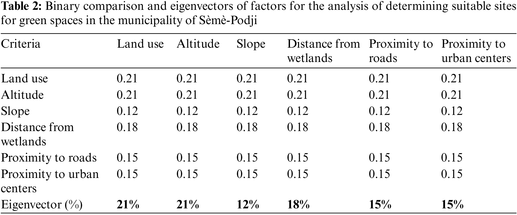
The evaluation of factor weights is a fundamental component of suitability analysis, generally derived from a blend of tacit knowledge, personal experiences, and individual judgments [42]. In this study, the weighting of the factors was performed using the Analytic Hierarchy Process (AHP) [43]. This involved a pairwise comparison of the criteria based on their relative importance to the established objective, utilizing a scaling system outlined in [44]. The derived weights from these comparisons were then used to verify the consistency of the significance attributed to each factor.
To implement this, a binary comparison matrix was constructed among the stakeholders to ensure that the weights reflected a comprehensive view of the priorities. Indeed, the weights assigned to the factors are judgments derived from a good knowledge of the field by the respondents and the norms for the installation of sustainable green spaces.
The consistency index (CI) is defined by the following equation:
where λ max is the maximum eigenvalue of each factor in the matrix table and n is the size of the matrix.
Then, the consistency ratio (CR), which represents the ratio between the consistency index (CI) and a random consistency index (RI), is calculated to indicate the reliability of the matrix judgments. Its value must be less than or equal to 0.1 to confirm the consistency of the matrix [44]. The consistency ratio (CR) is defined by the equation:
where (CR) is the consistency ratio, and (RI) is the random index developed by [44].
2.3.5 Overlay of Factors by Weighting Summation for Suitability Map and Decision-Making in Planning
The final step in the analysis involved the weighted summation of factors using GIS tools. The ``Spatial Analysis Tool" extension in ArcMap was utilized to aggregate the weighted factors and generate the suitability map for green space installation in the Sèmè-Podji District. This method is a general modeling approach based on the equation for developing suitability maps [27,45]. The formula used for this purpose was:
where A = Suitability for the installation of green spaces; Fi = Selected factor, and pi = Weight or importance of the considered factor.
This section describes the process and findings from identifying and prioritizing factors for sustainable green space installation in Sèmè-Podji District. It includes the selection and hierarchy of criteria, mapping and reclassification of each factor, their weighted aggregation based on importance, and the final analysis of the suitability map for green space installation.
3.1 Selection of Factors and Hierarchy of Criteria for Green Space Installation
An analysis of existing literature, spatial characteristics of the study area, and community feedback culminated in the identification of six key factors essential for determining suitable green space sites. These factors include land use, altitude, slopes, proximity to wetlands, accessibility to road networks, and proximity to major urban centers. The criteria for hierarchy of each of these factors are presented in Table 1.

The analysis of the Table 1 indicates that the most critical land use types for green space development are urban areas, followed by vegetative formations and agricultural lands. Altitude data show a general range from 0 to 21 m, with some areas falling below or exceeding this range. Slopes are mostly within 0% to 20%, though some exceed this percentage. Proximity to wetlands is a significant consideration, with a preference for locations at least 1000 m away. Accessibility within 300 m of road networks and 500 m of urban centers is highly valued for enhancing the utility and frequency of green space usage.
3.2 Maps of Factors Used for Identifying Suitable Sites for Green Space Installation in the Municipality of Sèmè-Podji
The land use status within the municipality is illustrated in Fig. 2a, showing current utilization, while Fig. 2b categorizes land use types according to their suitability for green space development. Altitude variations are detailed in Fig. 3a, ranging from −3 to 24 m, which help to identify different terrain types. Suitable altitudes for green spaces, as shown in Fig. 3b, are between 5 and 24 m, where urban and vegetative areas predominantly exist. Slope data, depicted in Fig. 4a, vary significantly across the district, affecting both infrastructure stability and environmental flow. The associated reclassification in Fig. 4b shows that most of the district features gentle slopes (0% to 5%), with steeper areas being relatively rare. Wetland distribution is mapped in Fig. 5a, with a focus on floodplains and water bodies mainly in the northern region. The suitability map in Fig. 5b suggests that areas over 500 m away from these wetlands are more favorable for green spaces due to lower flood risks. Road accessibility is crucial for green space utility, as mapped in Fig. 6a. The reclassified map in Fig. 6b indicates that green spaces within 300 to 900 m of roads are likely to be more frequented, aligning with community preferences for easy access. Lastly, the distribution of urban centers is captured in Fig. 7a, highlighting the south as a high-density area. Fig. 7b shows the reclassification based on proximity, indicating that green spaces within 500 m of these centers are likely to see higher visitation, with interest decreasing beyond 2000 m. All these figures are presented below.
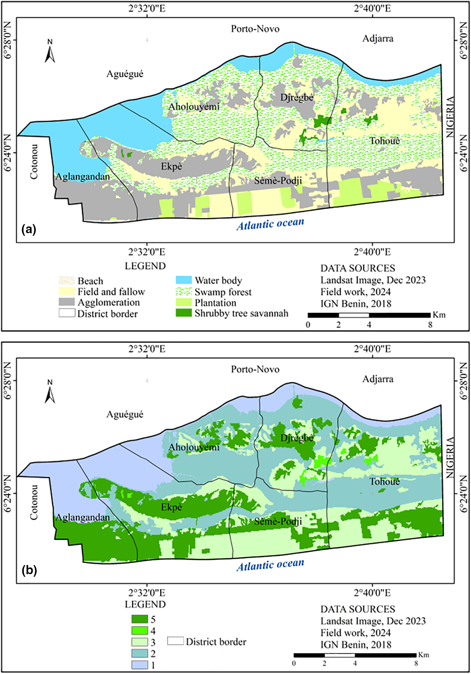
Figure 2: Land use map (a) and its reclassification, meaning the grouping of various factor classes (b)
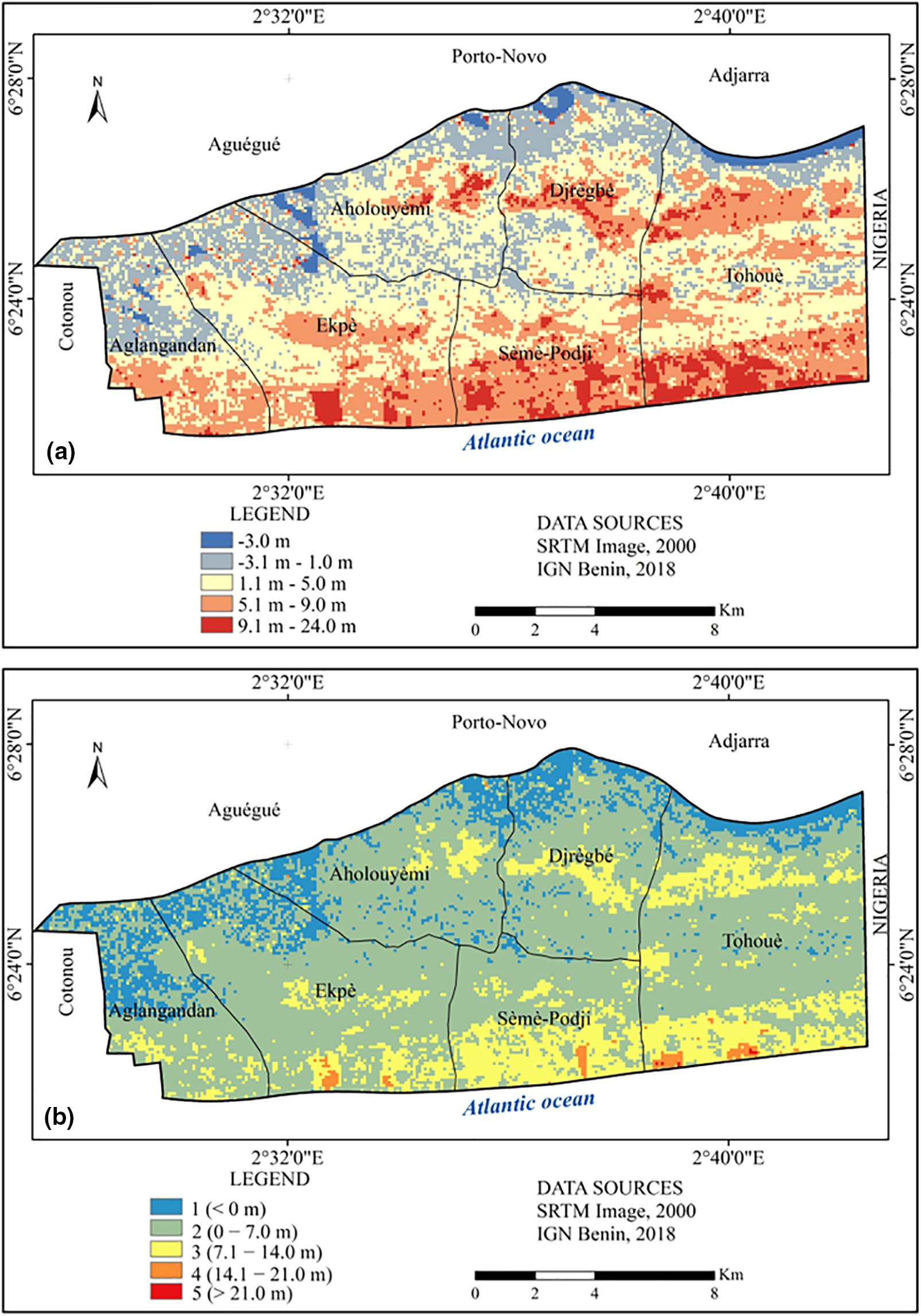
Figure 3: Elevation map (a) and its reclassification (b)
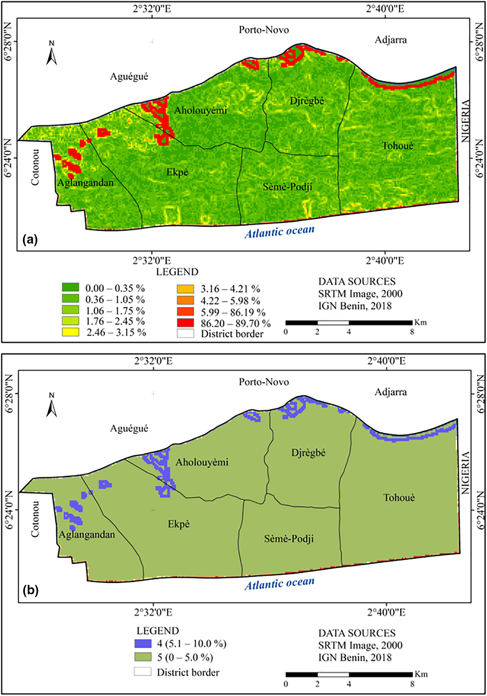
Figure 4: Slope map (a) and its reclassification (b)
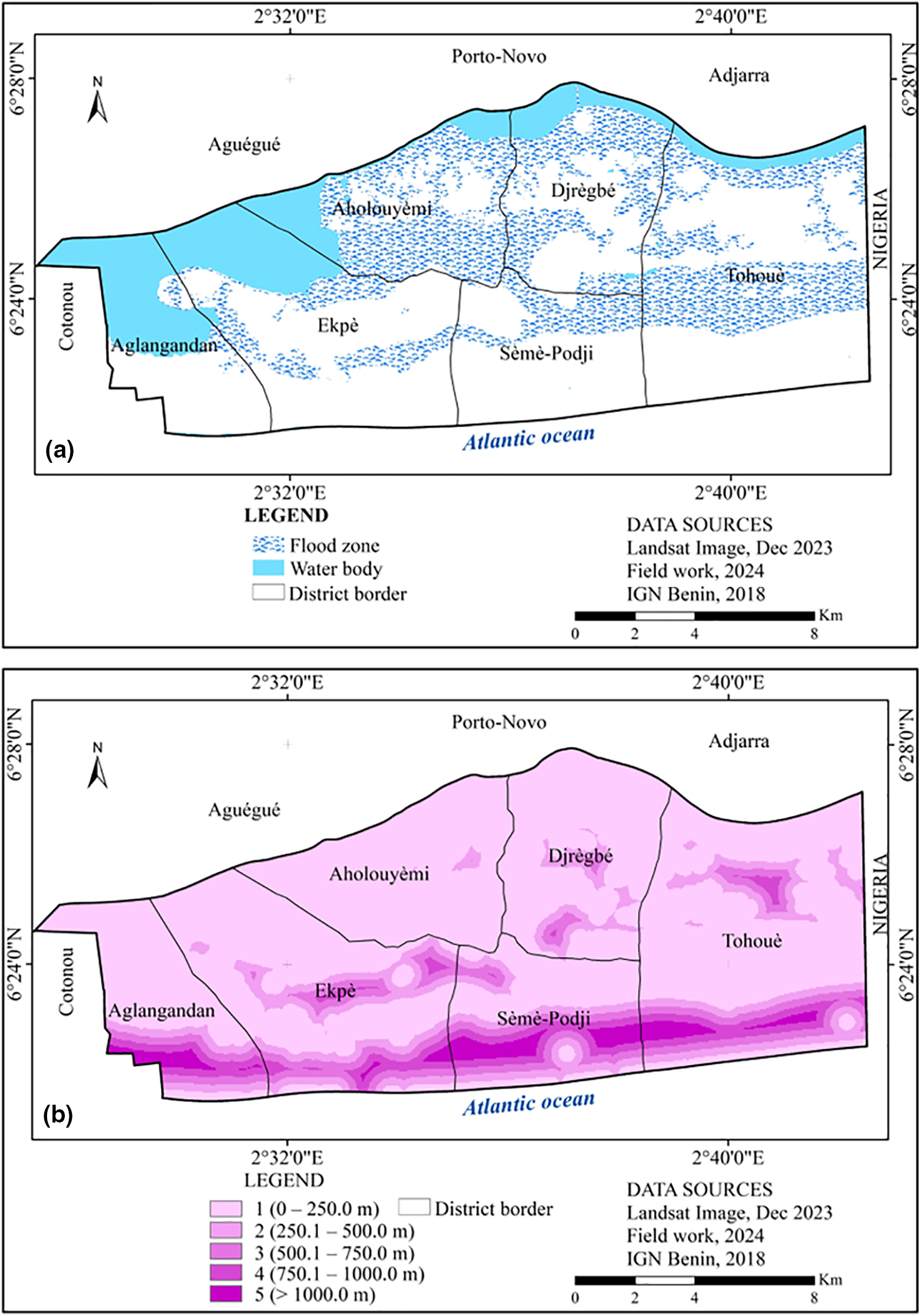
Figure 5: Flood-proneness map (a) and its reclassification (b)
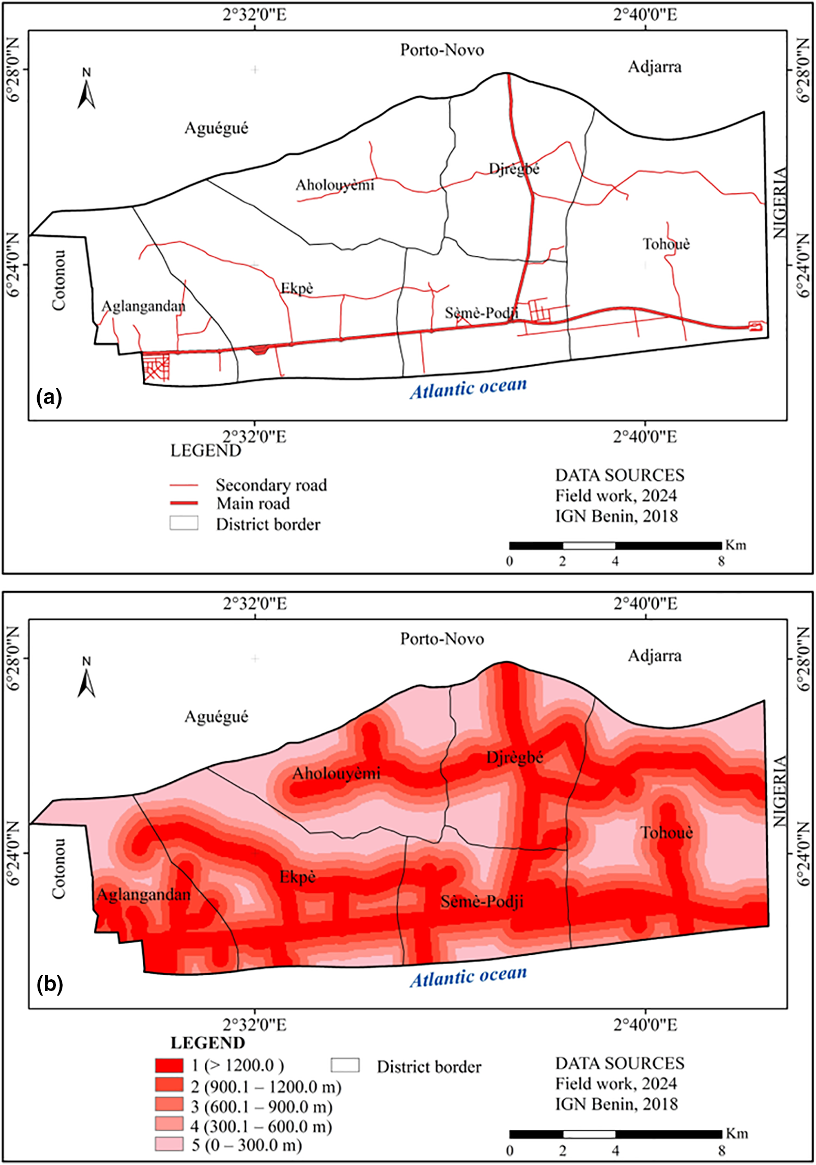
Figure 6: Road map (a) and its reclassification (b)
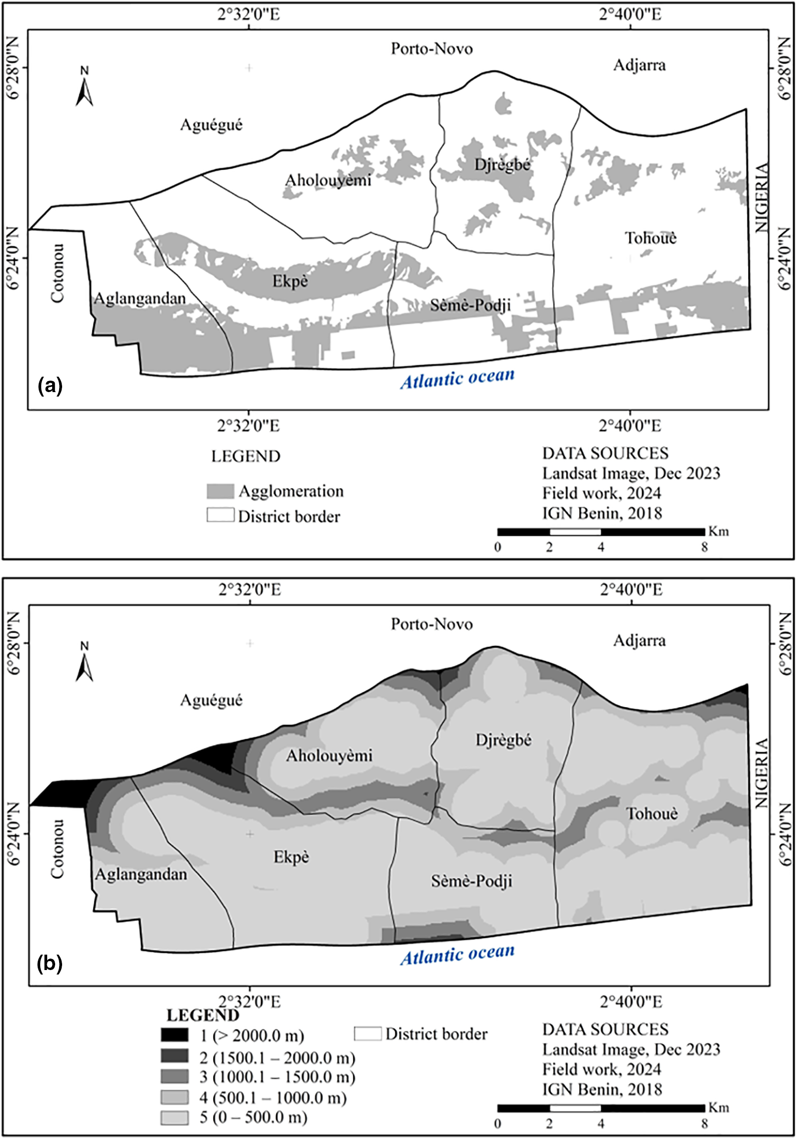
Figure 7: Urban centers map (a) and its reclassification (b)
3.3 Weighting of Criteria Using the Analytic Hierarchy Process (AHP)
Stakeholder judgments on factors influencing green space installation in Sèmè-Podji were evaluated using the Analytic Hierarchy Process (AHP), detailed in Table 2. This analysis revealed that land use and altitude are the most influential factors, each assigned a weight of 21%. The factor representing distance from wetlands was weighted at 18%, while proximity to roads and urban centers were equally valued at 15% each. The slope factor was given a weight of 12%. The resulting consistency index of 0.04, below the threshold of 0.1, confirms the coherence and reliability of these judgments for multicriteria analysis. This framework ensures that the selected lands are optimally suited for sustainable green space installation.
3.4 Analysis of the Suitability Map for Decision-Making in Planning
The suitability map, illustrated in Fig. 8, categorizes Sèmè-Podji district’s territory based on green space viability. Approximately 44.77% of the land is classified as highly suitable, primarily within densely populated and moderate-altitude areas. Suitable zones, making up 20.88% of the territory, are largely around urban centers. Less suitable zones account for 10.75% of the land, generally found on the fringes of more favorable areas. Moderately favorable and unfavorable zones comprise 10.64% and 12.96% of the district, respectively. Field verifications confirm that areas identified as highly suitable are correctly located within or near urban centers, validating the map’s effectiveness in guiding urban green space planning.
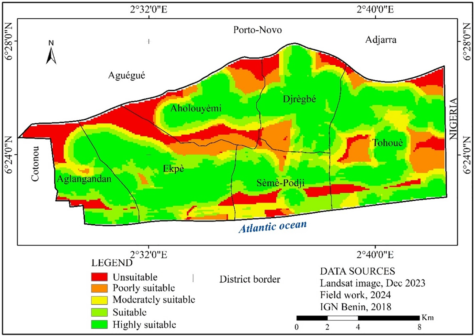
Figure 8: Suitable areas map for urban green spaces in Sèmè-Podji district
The pursuit of precision in decision-making based on coherent reasoning is increasingly adopted by development stakeholders. Among the methods used for this purpose, multicriteria analysis is often requested due to the quantification of the level of the resulting judgements [32,46]. In the field of planning, the multicriteria hierarchy approach is often coupled with Geographic Information Systems (GIS) for more precise in reasoning [19,31,47]. This is what the present study attempted to do by combining the main factors to develop a suitability map for the establishment of green spaces in the municipality of Sèmè-Podji. This is a hybrid technique [22] that overlays in a GIS, the weighted spatial layers, considered as determining factors in the creation of a suitability map [30].
Analysis revealed that flood-prone zones and water bodies are unsuitable for the development of green spaces, while agricultural lands show moderate suitability, corroborating studies [34,40] that have identified flood-prone zones and water bodies as less favorable. Urban regions and areas with dense vegetation emerged as the most suitable locations for these initiatives. Observations on the ground, supported by existing literature [35], indicate that the district’s terrain is predominantly flat or mildly sloping in residential areas, thus providing optimal conditions for the creation of green spaces. The topographic analysis of Sèmè-Podji displayed predominantly low slopes (0% to 5%), encompassing nearly the entire district, suggesting broad suitability for green space development [20,36].
It has been noted that the assigned weights to the six key factors play a significant role in shaping the distribution of potential green space sites within Sèmè-Podji. Further analysis using eigenvectors from the pairwise comparison of these factor weights revealed varying levels of importance [48]. The suitability map derived from this analysis shows that optimal locations for green spaces are typically in areas with low slopes and existing settlements. Approximately 65.65% of the district’s land has been identified as highly or moderately suitable, presenting opportunities for local developers to engage in sustainable urban planning. Despite this potential, the current scarcity of public green spaces signals a lack of prioritization by policymakers [12]. The outcomes of this study thus affirm the efficacy of this analytical approach in providing dependable data to decision-makers for potential green space projects [25]. To enhance decision-making, it is crucial to consider additional planning factors, such as the availability of land, subdivision plans, and administrative reserves [49]. These factors are essential for refining site selections to improve the urban quality of life for residents [10]. Another implication of this study is that it fits well with the greening program underway in the geographical area of Grand- Nokoué, in which the district of Sèmè-Podji is included. This program, which plans to promote not only natural spaces but also to install urban green spaces for recreation and attractiveness [50], will undoubtedly be able to use the results of this study for sustainable greening site choices. Finally, the suitability map offers the possibility of a rational use of space in the district of Sèmè-Podji, which helps to reduce social inequalities related to the accessibility of infrastructures in urban areas [51].
To achieve these results, the Saaty prioritization scale [43] played a key role. It is served as the basis for the binary comparison of the criteria for ranking each factor. This method has been used in various fields with success [23,52], and more specifically in the field of green space planning [27]. Indeed, the judgment of stakeholders can be subjective on a given subject. But to minimize these subjectivities, an evaluation of inconsistencies is made on the arguments used in the choice of factors and criteria by the different actors [53,54]. In the case of this study, it involved using the judgment of individuals who participated in the focus group to weigh the six determining factors in identifying sites suitable for green spaces in the municipality of Sèmè-Podji. This allowed to realize the necessity of considering them as an environmental requirement and as criteria for the population’s accessibility to green spaces [55,56]. Hence the importance of seeking coherence in the criteria for choosing green space installation sites [25]. The advantages of this analytical approach are its robustness and flexibility [57]. This allows it to be replicated in different socio-environmental contexts and on larger territories to objectively identify suitable spaces for the implementation of sustainable development projects.
The main limitation of this study lies in the number of factors used in the multicriteria analysis. Indeed, these factors could have been extended to others such as cadastral plan to further refine the results. Because, more the number of factors increases, better is the analysis [32]. Moreover, the lack of standard for the qualification of certain prioritization criteria, which requires relying on the judgment of the stakeholders.
This comprehensive study successfully delineated areas within the district of Sèmè-Podji that are optimally suited for the development of green spaces, employing a sophisticated multicriteria approach that integrates Geographic Information Systems (GIS) and the Analytic Hierarchy Process (AHP). Leveraging a set of realistically chosen criteria, the applied methodology adeptly weighted and amalgamated six pivotal factors, capturing the unique environmental and socio-cultural characteristics of the study area, guided by expert judgments.
The generation of a detailed suitability map is a significant outcome of this study, showcasing that an impressive expanse, exceeding 65% of Sèmè-Podji’s area, holds potential for green space development. It’s noteworthy that, amidst the diversity of factors considered, aspects such as land use, altitude, and proximity to wetlands emerged as critical priorities. This prioritization aligns seamlessly with both the stringent standards governing green space development and the distinctive socio-cultural landscape of Sèmè-Podji.
The methodological rigor and the coherent framework adopted for stakeholder decision-making underscore the study’s capacity to inform and shape sustainable urban development strategies within the municipality. By revealing extensive and previously underrecognized opportunities for green space development, this research not only contributes to enhancing urban sustainability but also to fostering healthier and more resilient communities in Sèmè-Podji.
Furthermore, the adaptability and scalability of the employed methodological approach offer a valuable blueprint for broader application across larger geographic expanses. This adaptability ensures that the approach can be tailored to meet the diverse stakeholder needs of development and decision-makers across various contexts, thereby facilitating more informed, strategic planning and implementation of territorial development initiatives.
In essence, this study not only underscores the tangible benefits of integrating technical precision with local knowledge in urban planning but also highlights the critical role of green spaces in the socio-environmental fabric of urban communities. It sets a precedent for future research and planning efforts, aiming at the holistic, sustainable development of urban territories.
Acknowledgement: The authors are grateful to the informants who took part in this research project. They are also thankful to the reviewers whose comments helped to improve this paper.
Funding Statement: The authors received no specific funding for this study.
Author Contributions: Conceptualization, data collection, data analysis, article writing and its correction, Abdel Aziz Osséni, Gbodja Houéhanou François Gbesso, Sedami Igor Armand Yevide and Etienne Romaric Adéwalé Godonou; Supervision, editing and validation before submission, Abdel Aziz Osséni and Gbodja Houéhanou François Gbesso. All authors reviewed the results and approved the final version of the manuscript.
Availability of Data and Materials: Data supporting the writing of this article are shown throughout tables and figures and are also available from the authors.
Conflicts of Interest: The authors declare that they have no conflicts of interest to report regarding the present study.
References
1. Medhi L, Weber C, Di Pietro F, Selmi W. Les services écosystémiques urbains, vers une multifonctionnalité des espaces verts publics : revue de littérature. Environ Urbain. 2017;11:1–20 (In French). [Google Scholar]
2. Breen A, Giannotti E, Flores-Molina M, Vasquez A. From government to governance? A systematic literature review of research for urban green infrastructure management in Latin America. Front Sustain Cities. 2020;2:572360. doi:10.3389/frsc.2020.572360. [Google Scholar] [CrossRef]
3. Hernandez J, Pallagst K, Hammer P. Urban green spaces as a component of an ecosystem functions, services, users, community involvement, initiatives and actions. Int J Environ Sci Nat Resour. 2018;8(1):24–39. [Google Scholar]
4. Cornet X. L’infrastructure verte dans l’aire urbaine de Montréal : la multifonctionnalité des espaces végétalisés en question. Vertigo. 2020;20(3):1–24 (In French). doi:10.4000/vertigo.28783. [Google Scholar] [CrossRef]
5. Girma Y, Terefe H, Pauleit S, Kindu M. Urban green infrastructure planning in Ethiopia: the case of emerging towns of Oromia special zone surrounding Finfinne. J Urban Manag. 2019;8:75–88. [Google Scholar]
6. Amraoui SM, Rouchdi M, Bouziani M, El Idrissi A. Intégration du SIG et de l’analyse hiérarchique multicritère pour l’aide dans la planification urbaine : etude de cas de la province de Khemisset. Maroc Papeles de Geografía. 2017;63:71–90 (In French). doi:10.6018/geografia/2017/280211. [Google Scholar] [CrossRef]
7. Pokhrel S. Green space suitability evaluation for urban resilience: an analysis of Kathmandu Metropolitan city, Nepal. Environ Res Commun. 2019;1(10):105003. doi:10.1088/2515-7620/ab4565. [Google Scholar] [CrossRef]
8. Salbitano F, Borelli S, Conigliaro M, Chen Y. Directives sur la foresterie urbaine et périurbaine. Forêts, Rome: Étude FAO; 2017 (In French). [Google Scholar]
9. Cilliers S, Cilliers J, Lubbe R, Siebert S. Ecosystem services of urban green spaces in African countries—perspectives and challenges. Urban Ecosyst. 2013;16(4):681–702. doi:10.1007/s11252-012-0254-3. [Google Scholar] [CrossRef]
10. Mili M, Boutabba H, Boutabba SD. La nature urbaine: dégradation quantitative et qualitative des espaces verts urbains, cas de la ville steppique de M’Sila, Algérie. Urbe Rev Bras Gest Urbana. 2019;11 (In French). doi:10.1590/2175-3369.011.e20180138. [Google Scholar] [CrossRef]
11. Amontcha AM, Djego JG, Lougbegnon TO, Sinsin BA. Typologie et répartition des espaces verts publics dans le Grand Nokoué (Sud Bénin). Eur Sci J. 2017;13(21):79–97 (In French). doi:10.19044/esj.2017.v13n21p79. [Google Scholar] [CrossRef]
12. Sehoun LC, Osseni AA, Orounladji M, Lougbegnon TO, Codjia JCT. Diversité floristique des formations végétales urbaines au Sud du Bénin (Afrique de l’Ouest). Rev Marocaine Sci Agron Vét. 2021;9(2):266–73 (In French). [Google Scholar]
13. Osseni AA, Gbesso GHF, Akabassi GC, Akakpo BA. Spatial diagnosis and conceptualisation of greening plan of Seme-Podji, Benin (West Africa). J Environ Geogr. 2023;16(1–4):22–30. doi:10.14232/jengeo-2023-44431. [Google Scholar] [CrossRef]
14. INSAE. Effectifs de la population des villages et quartiers de ville du Bénin (RGPH-4, 2013). Institut national de la statistique et de l’analyse economique (INSAE); 2016 (In French). [Google Scholar]
15. Kouadio YJC, Vroh BTA, Bi ZBG, Yao CYA, N’guessan KE. Évaluation de la diversité et estimation de la biomasse des arbres d’alignement des communes du Plateau et de Cocody (Abidjan - Côte d’Ivoire). J Appl Biosci. 2016;97:9141–51 (In French). doi:10.4314/jab.v97i1.1. [Google Scholar] [CrossRef]
16. Kenney WA, Wassenaer PJE, Satel AL. Criteria and indicators for strategic urban forest planning and management. Arboric Urban For AUF. 2011;37(3):108–17. doi:10.48044/jauf.2011.015. [Google Scholar] [CrossRef]
17. Fuwape JA, Onyekwelu JC. Urban forest development in West Africa: benefits and challenges. J Biodivers Ecol Sci. 2011;1(1):77–94. [Google Scholar]
18. Livesley SJ, McPherson GM, Calfapietra C. The urban forest and ecosystem services: impacts on urban water, heat, and pollution cycles at the tree, street, and city scale. J Environ Qual. 2016;45(1):119–24. doi:10.2134/jeq2015.11.0567. [Google Scholar] [PubMed] [CrossRef]
19. Cetin M. Using GIS analysis to assess urban green space in terms of accessibility: case study in Kutahya. Int J Sust Dev World Ecol. 2015;22:420–4. [Google Scholar]
20. Li Z, Fan Z, Shen S. Urban green space suitability evaluation based on the AHP-CV combined weight method: a case study of Fuping county, China. Sustainability. 2018;10(8):2656. doi:10.3390/su10082656. [Google Scholar] [CrossRef]
21. Cakir S, Hecht R, Krellenberg K. Sensitivity analysis in multi-criteria evaluation of the suitability of urban green spaces for recreational activities. Agile Gisci Ser. 2021;2:1–8. doi:10.5194/agile-giss-2-22-2021. [Google Scholar] [CrossRef]
22. Ozsahin E, Ozdes M, Smith AC, Yang D. Remote sensing and GIS-based suitability mapping of termite habitat in the African Savanna: a case study of the lowveld in Kruger National Park. Land. 2022;11(6):803. doi:10.3390/land11060803. [Google Scholar] [CrossRef]
23. Olayiwola A, Suleiman U. Site suitability analysis for landfill in an industrial area in Nigeria. J Environ Geogr. 2022;15(1–4):1–10. doi:10.14232/jengeo-2022-43938. [Google Scholar] [CrossRef]
24. Abebe WT, Endalie D. Artificial intelligence models for prediction of monthly rainfall without climatic data for meteorological stations in Ethiopia. J Big Data. 2023;10(1):1–15. doi:10.1186/s40537-022-00683-3. [Google Scholar] [CrossRef]
25. Gelan E. GIS-based multi-criteria analysis for sustainable urban green spaces planning in emerging towns of Ethiopia: the case of Sululta town. Environ Syst Res. 2021;10(1):3. doi:10.1186/s40068-021-00220-w. [Google Scholar] [CrossRef]
26. Lotfata A. Using remote sensing in monitoring the urban green spaces: a case study in Qorveh, Iran. Eur J Environ Earth Sci. 2021;2(1):11–5. doi:10.24018/ejgeo.2021.2.1.102. [Google Scholar] [CrossRef]
27. Linh NHK, Tung PG, Chuong HV, Ngoc NB, Phuong TT. The application of geographical information systems and the analytic hierarchy process in selecting sustainable areas for urban green spaces: a case study in Hue City, Vietnam. Climate. 2022;10(6):82. doi:10.3390/cli10060082. [Google Scholar] [CrossRef]
28. Commune de Sèmè-Podji. Plan de développement de la commune de Sèmè-Podji : Document programmation. Bénin: République du Bénin; 2006. p. 104 (In French). [Google Scholar]
29. Stalmeijer RE, Mcnaughton N, van Mook WNKA. Using focus groups in medical education research: AMEE Guide No. 91. Med Teach. 2014;36:923–39. doi:10.3109/0142159X.2014.917165. [Google Scholar] [PubMed] [CrossRef]
30. Kacem L, Agoussine M, Igmoullan M, Amar H, Mockhtari S, Ait Brahim Y. Application de la méthode d’analyse multicritère hiérarchique pour la quantification de perte en sol dans un sous-bassin montagnard - haute vallée de Tifnoute (Haut Atlas marocain). Geo Eco Trop. 2017;41:493–502 (In French). [Google Scholar]
31. Osseni AA, Dossou-Yovo HO, Gbesso GHF, Sinsin B. GIS-based multi-criteria analysis for selecting suitable areas for urban green spaces in abomey-Calavi district, Southern Benin. Land. 2023;12:1553. doi:10.3390/land12081553. [Google Scholar] [CrossRef]
32. Ustaoglu E, Aydınoglu AC. Site suitability analysis for green space development of Pendik district (Turkey). Urban For Urban Green. 2020;47(1):126542. doi:10.1016/j.ufug.2019.126542. [Google Scholar] [CrossRef]
33. Nguyen TTM, Nguyen HTT, Doan T, Tri DQ. Application analytic hierarchical process (AHP) in setting up local community urban environmental quality of life index in a developed metropolitan area in Ho Chi Minh City, Vietnam.Curr Urban Stud. 2021;9:376–91. [Google Scholar]
34. Dağıstanlı C, Turan İD, Dengiz O. Evaluation of the suitability of sites for outdoor recreation using a multi-criteria assessment model. Arab J Geosci. 2018;11(17):492. doi:10.1007/s12517-018-3856-0. [Google Scholar] [CrossRef]
35. Piran H, Maleknia R, Akbari H, Soosani J, Karami O. Site selection for local forest park using analytic hierarchy process and geographic information system (case study: Badreh County). Int Res J Appl Basic Sci. 2013;6(7):930–5. [Google Scholar]
36. Mahdavi A, Niknejad M. Site suitability evaluation for ecotourism using MCDM methods and GIS: case study—Lorestan Province, Iran. J Biodivers Environ Sci. 2014;4:425–37. [Google Scholar]
37. Mahmoud AHA, El-Sayed MA. Development of sustainable urban green areas in Egyptian new cities: the case of El-Sadat City. Landsc Urban Plan. 2011;101(2):157–70. doi:10.1016/j.landurbplan.2011.02.008. [Google Scholar] [CrossRef]
38. Bunruamkaew K, Murayam Y. Site suitability evaluation for ecotourism using GIS & AHP: a case study of Surat Thani Province, Thailand. Procedia—Soc Behav Sci. 2011;21(1):269–78. doi:10.1016/j.sbspro.2011.07.024. [Google Scholar] [CrossRef]
39. Kienast F, Degenhardt B, Weilenmann B, Wäger Y, Buchecker M. GIS-assisted mapping of landscape suitability for nearby recreation. Landsc Urban Plan. 2012;105(4):385–99. doi:10.1016/j.landurbplan.2012.01.015. [Google Scholar] [CrossRef]
40. Morckel V. Using suitability analysis to select and prioritize naturalization efforts in legacy cities: an example from Flint, Michigan. Urban For Amp Urban Green. 2017;27:343–51. [Google Scholar]
41. Peng J, Ma J, Du Y, Zhang L, Hu X. Ecological suitability evaluation for mountainous area development based on conceptual model of landscape structure, function, and dynamics. Ecol Indic. 2016;61(3):500–511. doi:10.1016/j.ecolind.2015.10.002. [Google Scholar] [CrossRef]
42. Jahn R, Blume HP, Asio V, Spaargaren O, Schád P. FAO guidelines for soil description, 2006. In: Adimi OSC, Oloukoi J, Tohozin CAB, editors. Analyse spatiale multicritère et identification des sols propices à la production du maïs à Ouessè au Bénin. VertigO - la revue électronique en sciences de l’environnement. Rome, Italie; 2006. doi:10.4000/vertigo.19885. [Google Scholar] [CrossRef]
43. Saaty TL. Decision making with the analytic hierarchy process. Int J Serv Sci. 2008;1(1):83–98. doi:10.1504/IJSSCI.2008.017590. [Google Scholar] [CrossRef]
44. Saaty TL. A scaling method for priorities in hierarchical structures. J Math Psychol. 1977;15(3):234–81. doi:10.1016/0022-2496(77)90033-5. [Google Scholar] [CrossRef]
45. Malczewski J, Rinner C. Exploring multicriteria decision strategies in GIS with linguistic quantifiers: a case study of residential quality evaluation. J Geogr Syst. 2005;7(2):249–68. doi:10.1007/s10109-005-0159-2. [Google Scholar] [CrossRef]
46. Javadian M, Shamskooshki H, Momeni M. Application of sustainable urban development in environmental suitability analysis of educational land use by using AHPand GIS. Tehran Procedia Eng. 2011;21:72–80. [Google Scholar]
47. Galdavi S, Mohammadzadeh M, Mirkarimi SH, Salman Mahiny A. Suitable site selection for urban parks and green spaces development. Geogr Plann Space Q J. 2022;12(2):117–32. doi:10.30488/GPS.2022.309469.3459. [Google Scholar] [CrossRef]
48. Toro J, Duarte O, Requena I, Zamorano M. Determining vulnerability importance in environmental impact assessment: the case of Colombia. Environ Impact Assess Rev. 2012;32(1):107–17. doi:10.1016/j.eiar.2011.06.005. [Google Scholar] [CrossRef]
49. Zannou S, Fangnon B, Doussou-Guedegbe O. Urbanisation et problématique de gestion de l’espace dans l’arrondissement de Dangbo au Bénin. In: Mélange en l’hommage au Professeur Emérite N’BESSA D. Benoit; 2018. p. 7–23 (In French). [Google Scholar]
50. Besteliu I, Toubin M, Renault P, Houngnon A, Adjehounou A, Osseni AA, et al. Mission de maitrise d’œuvre du programme de verdissement du Grand-Nokoué : Rapport d’état des lieux, République du Bénin; 2021 (In French). [Google Scholar]
51. Spielman S, Tuccilo J, Folch D, Schweikert A, Davies R, Wood N, et al. Evaluating social vulnerability indicators: criteria and their application to the social vulnerability index. Nat Hazards. 2020;100(1):417–36. doi:10.1007/s11069-019-03820-z. [Google Scholar] [CrossRef]
52. Ramos A, Cunha L, Cunha P. Application de la Méthode de l’Analyse Multicritère Hiérarchique à l’étude des glissements de terrain dans la région littorale du centre du Portugal : figueira da Foz–Nazaré. Geo Eco Trop. 2014;38:33–44 (In French). [Google Scholar]
53. Jeddou MB, Kalboussi WB, Dhouibi A. Application de la méthode AHP pour le choix multicritère des fournisseurs. Revue Marocaine de Recherche en Manag et Market. 2015;12:60–71 (In French). [Google Scholar]
54. Nourani A, Kaci F, Bouaziz M. Analyse hiérarchique multicritères pour évaluer des élévateurs à nacelles intervenant au sommet de palmier dattier using a hierarchical multi-criteria analysis to evaluate elevators for server the date palm crown. Revue Agric. 2016;12:4–11 (In French). [Google Scholar]
55. Ngom R, Gosselin P, Blais C. Reduction of disparities in access to green spaces: their geographic insertion and recreational functions matter. Appl Geogr. 2016;66:35–51. [Google Scholar]
56. Zhou S, Chen G, Fang L, Nie Y. GIS-based integration of subjective and objective weighting methods for regional landslides susceptibility mapping. Sustainability. 2016;8(4):334. doi:10.3390/su8040334. [Google Scholar] [CrossRef]
57. Yan F, Zhang Q, Ye S, Ren B. A novel hybrid approach for landslide susceptibility mapping integrating analytical hierarchy process and normalized frequency ratio methods with the cloud model. Geomorphology. 2019;327(1):170–87. doi:10.1016/j.geomorph.2018.10.024. [Google Scholar] [CrossRef]
Cite This Article
 Copyright © 2024 The Author(s). Published by Tech Science Press.
This work is licensed under a Creative Commons Attribution 4.0 International License , which permits unrestricted use, distribution, and reproduction in any medium, provided the original work is properly cited.
 Downloads
 Citation Tools