 Open Access
ARTICLE
Dynamiques Spatio-Temporelles de l’Occupation des Terres dans les Zones de Production Cotonnière et Céréalière au Mali
Spatio-Temporal Dynamics of Land Use in Cotton and Cereal Production Zones, Mali
1 Laboratoire d’Agroéconomie et d’Agrobusiness (LAGEC-B), Ecole Doctorale des Sciences Agronomiques et de l’Eau (EDSAE), Université d’Abomey-Calavi (UAC), Cotonou, 01 BP 526, Bénin
2 Institut d’Economie Rurale (IER), Rue Mohamed V, Bamako, BP 258, Mali
3 Laboratoire de Cartographie, Télédétection et SIG (LaCarto), Université d’Abomey Calavi, Cotonou, 10PB 1082, Houéyiho Bénin
4 Faculté des Sciences Economiques et de Gestion (FSEG), Université des Sciences Sociales et de Gestion de Bamako (USSGB), Bamako, BP 276, Mali
5 Laboratoire d’Ecologie Appliquée, Université d’Abomey-Calavi (UAC), Cotonou, 01 BP 526, Bénin
* Corresponding Authors: Moumouni Sidibé. Email: ; Yaya Issifou Moumouni. Email:
Revue Internationale de Géomatique 2024, 33, 51-76. https://doi.org/10.32604/rig.2024.045505
Received 29 August 2023; Accepted 20 February 2024; Issue published 05 April 2024
RÉSUMÉ
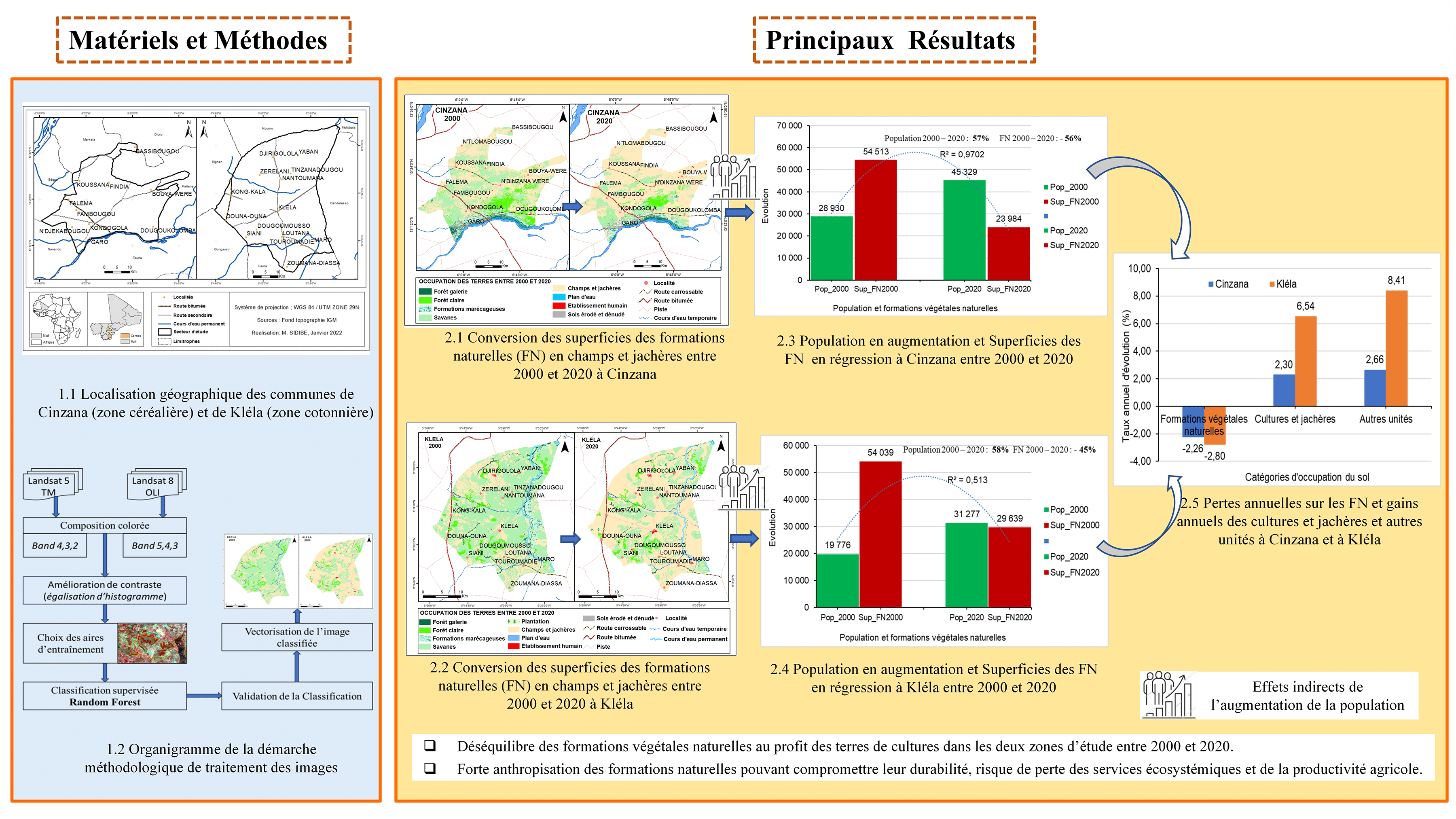
La dynamique d’occupation des terres constitue un préalable pour l’identification des contraintes de gestion des ressources naturelles, l’évolution de pratiques agraires et la croissance démographique. L’objectif de cette recherche est d’améliorer les connaissances sur la dynamique d’occupation des terres agricoles dans les zones de cultures sèches (Cinzana) et cotonnière (Kléla) au Mali. La méthodologie utilisée a consisté à la collecte des données planimétriques et à l’analyse diachronique à travers des images satellitaires Landsat TM (Thematic Mapper) de 2000 et OLI (Operational Land Image) de 2020. Les taux de dégradation et de déforestation des formations naturelles ont été calculés d’une part et d’autre part la vitesse et l’intensité des changements ont été évaluées à l’aide des programmes « Pontius matrix 22 et intensity analysis » à partir de la matrice de transition. Les résultats de l’analyse diachronique ont révélé une nette augmentation des superficies des formations anthropiques, notamment celles des champs et jachères au détriment des formations naturelles. Cela s’est manifesté à Cinzana par une augmentation globale des superficies des formations anthropiques de 45% (soit 2,30% par an), et une réduction globale de 45,15% (2,26% par an) des superficies des unités naturelles ; à Kléla par une progression globale de 131% (soit 6,54%/an) des champs et jachères au détriment des formations naturelles qui ont subi une réduction de 95% (soit 4,76% par an) entre 2000 et 2020. En somme, l’évolution des unités paysagères dans la zone de recherche entre 2000 et 2020 présage une anthropisation à outrance des formations naturelles, ce qui pourrait compromettre la durabilité de ces formations, avec un risque de perte des services écosystémiques et de la productivité agricole. L’étude recommande l’utilisation des pratiques agroécologiques, la facilitation de l’accès aux technologies agricoles, aux services d’encadrement dans une perspective d’intensification agricole. Les mesures politiques dans le sens d’une transition agroécologique doivent être encouragées.Abstract
Land use dynamics is a prerequisite for identifying natural resource management constraints, the evolution of agrarian practices and population growth. The objective of this research is to improve knowledge of the dynamics of agricultural land use in the dryland (Cinzana) and cotton (Kléla) areas of Mali. The methodology used consisted of planimetric data collection and diachronic analysis using Landsat TM (Thematic Mapper) satellite images from 2000 and OLI (Operational Land Image) from 2020. Degradation and deforestation rates of natural formations were calculated on the one hand, and on the other hand, the speed and intensity of changes were evaluated using the Pontius matrix22 and intensity analysis programs from the transition matrix. The results of the diachronic analysis revealed a clear increase in the area of anthropogenic formations, especially fields and fallow land, at the expense of natural formations. In Cinzana, this was reflected in an overall increase in the area of anthropogenic formations of 45% (i.e., 2.30% per year) and an overall reduction of 45.15% (2.26% per year) in the area of natural units. In Kléla, there was an overall increase of 131% (i.e., 6.54% per year) in the area of fields and fallow land to the detriment of natural formations, which underwent a reduction of 95% (i.e., 4.76% per year) between 2000 and 2020. Definitely, the evolution of landscape units in the research area between 2000 and 2020 points to excessive anthropization of natural formations, which could compromise the sustainability of these formations, with a risk to ecosystem services and agricultural productivity lost. The study recommends the use of agro-ecological practices, and the facilitation of access to agricultural technologies and support services with a view to agricultural intensification. Policy measures to promote an agro-ecological transition should be encouraged.Graphic Abstract

MOTS CLÉS
Keywords
Cite This Article
 Copyright © 2024 The Author(s). Published by Tech Science Press.
This work is licensed under a Creative Commons Attribution 4.0 International License , which permits unrestricted use, distribution, and reproduction in any medium, provided the original work is properly cited.


 Submit a Paper
 Propose a Special lssue
 View Full Text
 Download PDF
 Downloads
 Citation Tools